


SEDONA, Ariz. — Firefighters battling the Pocket Fire north of Sedona are beginning to make significant progress after successfully holding the fire’s northern edge through three consecutive days of critical fire weather.
According to Tuesday morning’s update from incident officials, the Pocket Fire has grown to 15,376 acres and remains 0% contained. The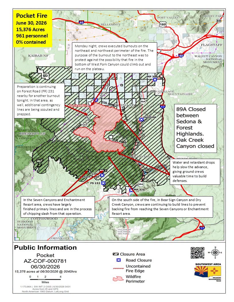 wildfire, which started on June 19, continues burning approximately 7 miles north of Sedona in timber and brush fuels. A total of 961 personnel are assigned to the incident.
Firefighters Hold Northern Line
Incident commanders reported that despite three days of Red Flag conditions, crews successfully stopped the fire’s northward progression at Forest Road 535. A welcome decrease in wind speeds on Monday allowed firefighters to shift from defensive operations to more aggressive firefighting tactics.
Overnight Monday, crews carried out strategic burnout operations along both the northeast and northwest edges of the fire. The northeast burnout was designed to prevent fire burning in the bottom of West Fork Canyon from climbing onto the plateau, while operations on the northwest side focused on protecting critical power transmission lines.
Additional burnout operations are planned again Tuesday night as firefighters continue strengthening containment lines.
Line Construction Continues South of the Fire
On the southern flank, firefighters continue building and reinforcing containment lines in Bear Sign Canyon and Dry Creek Canyon to prevent the fire from backing toward Seven Canyons and the Enchantment Resort.
Primary containment lines in the area are largely complete, with crews now chipping vegetation removed during line construction and preparing multiple contingency lines should fire activity increase.
Elsewhere around the fire, crews continue patrolling and mopping up established fire lines along Forest Roads 231, 536, 536A and 539 to ensure previously secured areas remain intact.
Aircraft are once again playing a major role in suppression efforts after calmer weather returned. Water and retardant drops are helping slow fire spread while infrared-equipped aircraft and drones identify hot spots and new areas of concern around the clock.
Fire managers continue working to protect Oak Creek Canyon, communities between Flagstaff and Sedona, power infrastructure, archaeological sites and sensitive natural resources.
Evacuations and Closures Remain in Effect
Sections of State Route 89A and Woody Mountain Road (Forest Road 231) remain closed due to fire activity. Because of ongoing guardrail work on SR 89A, residents of Oak Creek Canyon must currently access the canyon from the south.
A portion of the Coconino National Forest also remains closed to the public under Stage 2 Fire Restrictions, which took effect Tuesday morning.
Officials remind the public that a Temporary Flight Restriction (TFR) remains in place over the fire area. Unauthorized drone flights can ground firefighting aircraft and significantly hinder suppression efforts.
 Weather and Smoke Concerns
Tuesday’s forecast calls for sunny skies with a high near 87 degrees, sustained south winds around 16 mph with gusts up to 23 mph, and continued very low humidity. No precipitation is expected over the next several days.
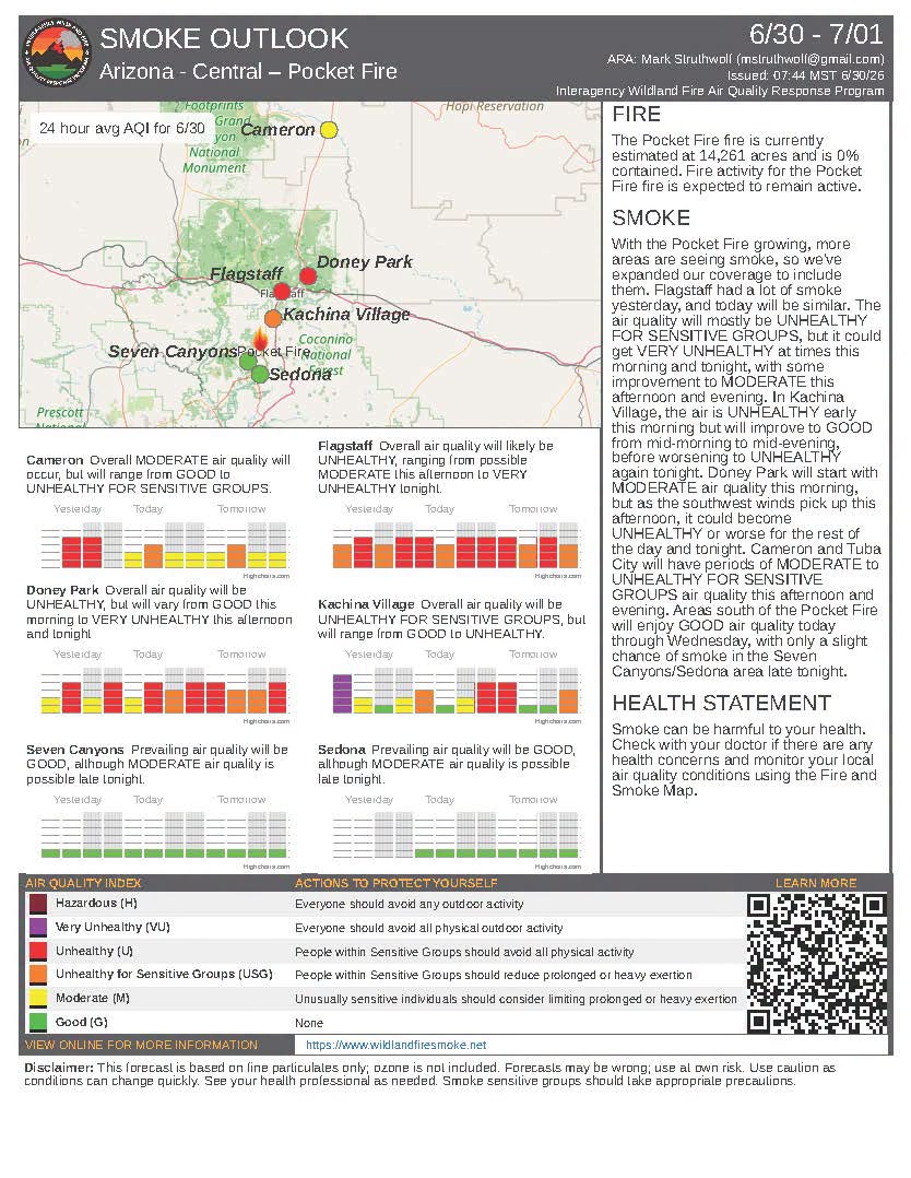
Smoke conditions continue to fluctuate throughout northern Arizona, with air quality ranging from Good to Very Unhealthy depending on location and changing weather conditions. Residents are encouraged to monitor local air quality and limit outdoor activity when smoke levels increase.
Motorists traveling through authorized areas are urged to use caution, as heavy firefighting equipment and personnel remain active throughout the incident area.
Flagscanner will continue providing updates as conditions change.